Salar de Uyuni (or Salar de Tunupa) is the world's largest
salt flat at 10,582 square kilometers (4,086 sq mi). It is located in the
Potosí and
Oruro departments in southwest
Bolivia, near the crest of the
Andes, and is elevated 3,656 meters (11,995 ft) above the mean sea level.
[1] The Salar was formed as a result of transformations between several prehistoric lakes. It is covered by a few meters of salt crust, which has an extraordinary flatness with the average altitude variations within one meter over the entire area of the Salar. The crust serves as a source of salt and covers a pool of
brine, which is exceptionally rich in
lithium. It contains 50 to 70% of the world's lithium reserves,
[2] which is in the process of being extracted. The large area, clear skies and exceptional surface flatness make the Salar an ideal object for calibrating the
altimeters of the Earth observation satellites.
[3][4][5][6][7] The Salar serves as the major transport route across the Bolivian
Altiplano and is a major breeding ground for several species of pink
flamingos.
commonly known as
Santa Cruz, is the capital city of the
Santa Cruz department in eastern
Bolivia. The
municipality's population was 1,756,926 inhabitants in 2010 (official estimate
[2]) and the urban population is 2,102,998 in 2010 (official estimate)
[3] which makes it the largest city in Bolivia.
This article is about the South American country. For other uses, see
Bolivia (disambiguation).
Plurinational State of Bolivia
|
|
Motto: "¡La unión es la fuerza!" (Spanish)
"Unity is (the) strength!" |
| Anthem: Bolivianos, el hado propicio (Spanish) |
Wiphala of Qulla Suyu:
 |
|
| Capital | Sucre (constitutional capital)[1]
 19°2′S 65°15′W / 19.033°S 65.25°W / -19.033; -65.25 La Paz (seat of government) 19°2′S 65°15′W / 19.033°S 65.25°W / -19.033; -65.25 La Paz (seat of government)
 16°30′S 68°09′W / 16.5°S 68.15°W / -16.5; -68.15 16°30′S 68°09′W / 16.5°S 68.15°W / -16.5; -68.15 |
| Largest city | Santa Cruz de la Sierra
 17°48′S 63°10′W / 17.8°S 63.167°W / -17.8; -63.167 17°48′S 63°10′W / 17.8°S 63.167°W / -17.8; -63.167 |
| Official language(s) | Spanish
Quechua
Aymara
and 34 other native languages[2][3] |
| Ethnic groups | 55% Amerindian (Quechua and Aymara), 30% Mestizo, 15% White[4] |
| Demonym | Bolivian |
| Government | Unitary Presidential Republic |
| - | President | Evo Morales |
| - | Vice President | Álvaro García |
| Independence | from Spain |
| - | Declared | 6 August 1825 |
| - | Recognized | 21 July 1847 |
| Area |
| - | Total | 1,098,581 km2 (28th)
424,163 sq mi |
| - | Water (%) | 1.29 |
| Population |
| - | 2010 estimate |  10,907,778[5] (84th) 10,907,778[5] (84th) |
| - | 2001 census | 8,280,184 |
| - | Density | 8.9/km2 (210th)
23/sq mi |
| GDP (PPP) | 2009 estimate |
| - | Total | $45.523 billion[6] |
| - | Per capita | $4,451[6] |
| GDP (nominal) | 2009 estimate |
| - | Total | $17.464 billion[6] |
| - | Per capita | $1,707[6] |
| Gini (2006) | 59.2[7] (high) |
| HDI (2010) |  0.643[8] (medium) (95th) 0.643[8] (medium) (95th) |
| Currency | Boliviano (BOB) |
| Time zone | (UTC-4) |
| Drives on the | Right |
| ISO 3166 code | BO |
| Internet TLD | .bo |
| Calling code | +591 |
Coordinates:  16°42′43″S 64°39′58″W / 16.712°S 64.666°W / -16.712; -64.666 Bolivia
 (pronounced
/bəˈlɪviə/ ( listen)
), officially known as the
Plurinational State of Bolivia[9][10] (
Spanish:
Estado Plurinacional de Bolivia,
IPA: [esˈtaðo pluɾinasjoˈnal de βoˈliβja]), is a
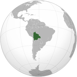
landlocked country in central
South America. It is bordered by
Brazil to the north and east,
Paraguay and
Argentina to the south, and
Chile and
Peru to the west.
Prior to
European colonization, the
Andean region of Bolivia was a part of the
Inca Empire - the largest state in
Pre-Columbian America. The
Spanish Empire conquered the region in the 16th century. During most of the Spanish colonial period, this territory was called
Upper Peru and was under the administration of the
Viceroyalty of Peru, which included most of
Spain's South American colonies. After declaring independence in 1809, 16 years of war followed before the establishment of the
Republic, named for
Simón Bolívar, on 6 August 1825. Bolivia has struggled through periods of political instability,
dictatorships and economic woes.
Bolivia is a
Democratic Republic that is divided into nine departments. Its geography is varied from the peaks of the
Andes in the West, to the Eastern Lowlands, situated within the Amazon Basin. It is a
developing country, with a Medium
Human Development Index score, and a poverty level around 60%. Its main economic activities include
agriculture,
forestry,
fishing,
mining, and
manufacturing goods such as textiles, clothing, refined metals, and
refined petroleum. Bolivia is very
wealthy in minerals, especially
tin.
The Bolivian population, estimated at 10 million, is
multiethnic, including
Amerindians,
Mestizos,
Europeans,
Asians and
Africans. The main language spoken is Spanish, although the
Aymara and
Quechua languages are also common and all three, as well as 34 other
indigenous languages, are official. The large number of different cultures within Bolivia has contributed greatly to a wide diversity in fields such as art, cuisine, literature, and music.
 16°42′43″S 64°39′58″W / 16.712°S 64.666°W / -16.712; -64.666 Bolivia (pronounced /bəˈlɪviə/ (


